Exploring Bryce Canyon National Park
- Heidi Hewett
- Apr 11, 2024
- 6 min read
Tom and I enjoyed four breathtaking but chilly days camping and hiking in Bryce Canyon National Park. The developed areas of Bryce Canyon National Park range in elevation from 7900 and 9100 feet and can get a lot of snow in the winter. Some parts of the park are closed during the winter and just started opening up when we arrived the second week of April.
Camping in North Campground
The North Campground is the only campground within the park that is open this early in the season. It's located near the park entrance, across from the Visitor Center. The General Store, with supplies, showers, and a laundromat, is just south of the campground near Sunrise Point.

North Campground has tent and RV sites but no hookups. Each site has a picnic table, fire pit, and barbecue grill. There are water pumps and bathrooms accessible throughout the campground.
The nightly fee, at the time of this post, is $30. However, if you have a National Park Senior Pass (62 and older) or an Access Pass (permanent disability) you can provide your pass number to get a 50% discount. I'm already looking forward to Tom's 62nd birthday at the end of this year!
Several private campgrounds and RV parks are located just outside the park entrance but Tom and I were happy to have quick access to the hiking trails, bike path, and shuttle bus right from our campsite. We enjoyed a Swiss Cheese Fondue dinner in our camper one night and a wonderful Cowboy Buffet at the historic Ruby's Inn, just outside the park, the next night.
Photos
You can view photos from the North Campground and surrounding areas on the Carpe Diem Facebook page by clicking on the image below.
Sunset to Inspiration Point via Rim Trail
After settling into our campsite, Tom and I walked to the Visitor Center to learn a little about the park and what to expect. It was just after noon and barely above freezing. We considered catching the free shuttle bus in front of the Visitor Center but decided to return to our camper and bundle up. We geared up for hiking then jumped in our Jeep to explore a little. Our first stop was the Sunset Point Overlook.
We had no idea what to expect when we parked near Sunset Point and walked to the edge of the canyon. The pine trees and snow near the parking lot could have been our back yard in Colorado. Minutes later we're standing on a cliff looking down into a canyon with endless towers of red rock formations.

Highlights
We couldn't take our eyes off the canyon as it led us along the Rim Trail. Every view was spectacular and just different enough from the previous view to warrant another picture. We didn't have a hiking plan but we didn't need one. The views led the way! Before we knew it, we had walked from Sunset Point to Lower, then Upper Inspiration Points. On one side of us was a snow-covered evergreen forest reminiscent of Rocky Mountain National Park. On the other side was a deep canyon with red rocks reminiscent of Arches National Park. By the time Tom and I hiked the 1.5 mile out-and-back from Sunrise Point to Upper Inspiration Point, we were inspired to do another hike. Fortunately there were plenty to choose from! When we returned to Sunrise Point, we saw a sign for the Navajo Loop Trail leading down into the canyon.
Photos
You can view photos from our 1.5 mile out-and-back hike between Sunset and Inspiration Points, via the Rim Trail, on the Carpe Diem Facebook page by clicking on the image below.
Navajo - Queens Garden Loop
Tom and I started down the Navajo Loop Trail knowing, from the sign posted above, that the Wall Street part of the loop was closed. We weren't sure how far we'd get but we couldn't resist the opportunity to view the beautiful Canyon from within. We resurfaced almost 3.5 miles later after connecting with the Queens Garden Trail!

Highlights
We passed Thor's Hammer as we descended the switchbacks into the canyon on the Navajo Trail. The switchbacks became relatively steep and extremely slick in the shaded areas. What wasn't icy, was slick with mud. We'd left our spikes in the Jeep and considered going back. But, with slow and careful footwork, we managed to make the descent without injuries or even mud stains. We stopped near the bottom for photos of Two Bridges then continued to the Queens Garden Trailhead.
Tom and I continued our hike through Queen's Garden with spectacular views in every direction. We walked through several small tunnels, one of which included a very small patch of ice. I didn't see the ice because I was too busy video taping my short walk through the tunnel. Ooops! Fortunately,, I caught by balance before falling. It would have been a long way for Tom to carry me back to the Jeep!
We passed the rock formation of Queen Victoria before starting our ascent to Sunrise Point. From there we followed the Rim Trail to our Jeep at Sunset Point.
It was a fantastic first day of hiking in Bryce Canyon National Park... even with the intermittent snow flurries!
Photos
You can view photos from our hike down the Navajo Loop Trail and through Queen's Garden on the Carpe Diem Facebook page by clicking on the image below.
Peekaboo Loop Trail
Inspired by our previous day's hikes, Tom and I woke up ready to hike the trails again... But, not too early. It was COLD outside! The overnight low was 18 degrees and the predicted high for the day was only about 40. We bundled up, packed our hiking spikes and walked to the Visitor Center to catch the shuttle bus. Tom and I didn't know where the day's adventure would lead us and figured wherever we ended up, we could catch the nearest shuttle back to camp. We got off the shuttle at it's farthest stop, Bryce Point.

Highlights
Tom and I started our hike with a short walk out to the Bryce Point Overlook. It's even higher than Inspiration Point, where we'd hiked the day before, with amazing views of the canyon. From Bryce Point we hiked down into the canyon and followed the Peekaboo Loop Trail. We returned to Bryce Point shuttle stop 3 hours, and 5.7 miles later after another great day in the park!
Photos
You can view photos from our hike along the Peekaboo Loop trail on the Carpe Diem Facebook page by clicking on the image below.
Southern Scenic Drive
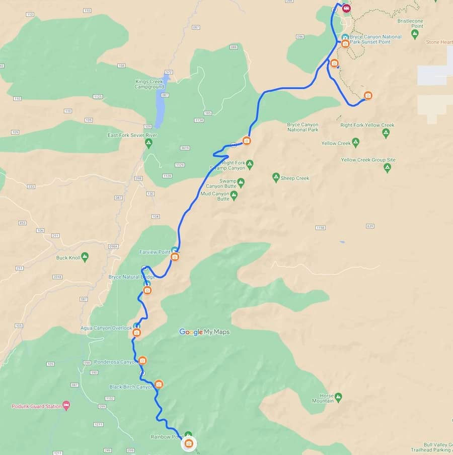
The Southern Scenic Drive is a 15 mile stretch of road between the Bryce Point turnoff and Rainbow Point. It offers beautiful views from the many overlook pullouts. Nearly all the pullouts are on the left, looking down into the canyon, as we headed to Rainbow Point. Tom and I drove all the way to the Rainbow Point without stopping. The farther we drove, the higher in elevation we climbed and noticeably more snow was covering the ground.

Highlights
Tom and I met some friends of ours for quick and chilly picnic lunch at the Rainbow Point Overlook. Then, together, we made our way back down the scenic drive stopping at most of the pullouts along the way. Even though the air was chilly, we enjoyed the beautiful clear blue sky!
Photos
You can view photos from our tour of the Southern Scenic Drive on the Carpe Diem Facebook page by clicking on the image below.
Fairyland Loop Trail
Our last full day in Bryce Canyon National Park was my birthday so I got to choose our activity. Much to Tom's chagrin, I chose an 8.6 mile hike along the Fairyland Loop trail. This trail is located at the north end of the park so we could access it from our campground without having to drive or take the shuttle.

Highlights
We enjoyed another beautiful day with clear blue skys as we started along the Rim trail then dropped into the canyon. The trail led through a variety of landscapes from desert to forests with snow and creeks along the way. The views of Tower Bridge were some of my favorite.
Photos
You can view photos from our hike along the Fairyland Loop trail on the Carpe Diem Facebook page by clicking on the image below.


Comments